
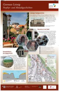
Georoute Leisnig: Porphyry stories and town history
Leisnig town history
Mildenstein Castle was built high above the Freiberger Mulde in the 10th century on a spur of volcanic porphyry rock. Under its protection, a market town developed in the 13th century – today’s old town centre. The inhabitants initially earned their livelihood from the grain trade and later also from cloth and canvas production. The connection to the railway network in the 1860s triggered a boom in the textile industry and attracted business travellers and guests to Leisnig: new hotels such as the ‘Belvedere’ were built.
Caption: Hotel ‘Belvedere’ at the end of the 19th century, basement made of Leisnig quartz porphyry, today revitalised as the Forte Belvedere cultural venue.
The stones that made the town
The character of Leisnig’s old town has changed over the centuries. The houses preserved today mostly date from the reconstruction period following the last town fire in 1803. Simple foundation and retaining walls were built from Leisnig quartz porphyry, quarried in the quarries along the Mulde river. Portals and window jambs, on the other hand, are stone carvings made of porphyry tufa from the Rochlitz and Chemnitz regions. In the second half of the 19th century, Elbe sandstone was also increasingly used and was brought in by the railway.
Captions
View from Niederlanggasse to Mildenstein Castle on the Leisnig Georoute.
1 – Seating niche portal made of Rochlitz porphyry tuff and wall made of Leisnig quartz porphyry, Lichtenberggasse 4, inscription dated 1710, Renaissance style.
2 – Door and window jambs made of Hilbersdorf porphyry tuff (‘Zeisigwald tuff’), Niederlanggasse 23, built around 1850, Classicist style.
3 – House portal made of Cotta Elbe sandstone, former Muldenstrasse 15, built as a gateway in the 1930s.
4 – „Donkey well“ made of Rochlitz porphyry tuff (K. Loose, 1938); originally a watering place for the donkeys used to transport grain, with quartz porphyry rocks behind it.
5 – Water feature in Kirchstrasse: volcanic rocks from Finland and Sweden; transported by the ice-age inland glaciers (erratic boulders).
A telescopic view into earth history
Between 298 and 290 million years ago (Permian period), a supervolcanic event took place in the region between Rochlitz and Grimma, during which thousands of cubic kilometres of rock mass were ejected and a collapse depression (Rochlitz caldera) was formed. The Leisnig quartz porphyry and Rochlitz porphyry tuff volcanic rocks were also formed in the process. Around 350,000 years ago (Pleistocene, Ice Age), the northern European inland glaciers moved across the region and exposed the porphyry rocks. For almost 100,000 years, the river Freiberger Mulde has been cutting deeper and deeper into the porphyry rocks: The Belvedere telescope lety you zoom in on the geology of the region.
BU: Seen through the telescope: Walls of reddish-brown Leisniger quartz porphyry on the Riedelsteig above the Mulde.
Caption: Geological profile section along the telescope view from Forte Belvedere.
Georoute Leisnig: Porphyry stories and town history
Between 298 and 290 million years ago (Permian period), a supervolcanic event took place in the region between Rochlitz and Grimma, during which thousands of cubic kilometre
1 InfoPanel location, view of the Mulde valley on the Riedelsteig trail
2 Water feature (erratic boulders)
3 View of Mildenstein Castle
4 Stairs closed in winter – use the connection via Schlossberg and Burglehn
5 „Donkey Well“
6 Luther benches – view of the Mulde valley
Imprint
Concept and texts: In co-operation with Forte Belvedere / M. J. Kellner, Leisnig History and Local History Association, Leisnig Town Visitors‘ Office;
Photos: Deutsche Fotothek: SLUB/KS B8646, Mirko J. Kellner, Rebecca Heinze, Marion Geißler;
Geological section and map: GEOmontan GmbH Freiberg;
Design: Lars Hoschkara, DESIGN & MULTIMEDIA (Wermsdorf)